Mayan Ruins
Chitzen Itza Mayan Ruins
Chichen Itza was a Mayan city on the Yucatan Peninsula in Mexico. Although it’s an important tourist attraction, Chichen Itza also remains an active archeological site. New discoveries are still being unearthed in the area, providing even more insight into the culture and accomplishments of the Mayan people, who ruled much of present-day Mexico and Central America prior to the arrival of European colonists. Chichen Itza was named a UNESCO World Heritage Site in 1988 and, in 2007, it was voted in a global survey as one of the New Seven Wonders of the World.
The name Chichen Itza is a Mayan language term for “at the mouth of the well of the Itza.” The Itza were an ethnic group of Mayans who had risen to power in the northern part of the Yucatan peninsula, where the city is located. The well in the name refers to a number of underground rivers that run beneath the region and likely served as the source of water for the city. This easy access to water made the location perfect for a city the size of Chichen Itza.
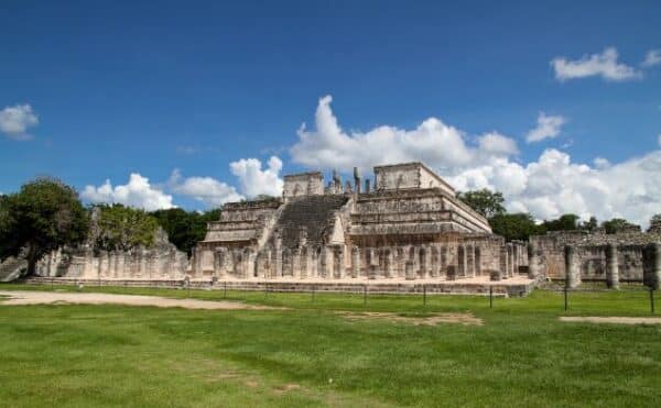
Historic accounts differ as to when Chichen Itza was built and ultimately developed into a center of political and economic power. Some accounts place the establishment of the city in the early 400s A.D., while others suggest construction started a few years later, in the middle part of the fifth century. What isn’t up for debate is that Chichen Itza was a significant center of political and economic activity in the Mayan culture by roughly 600 A.D. By then, it was already one of the largest cities in the Mayan world, covering nearly two square miles with densely packed commercial, residential and other structures made of stone. Chichen Itza even had its own “suburbs,” with smaller homes occupying the outskirts of the city.
Remarkably, given the relatively simple technology available at the time, Chichen Itza was built in an area of rough terrain that was leveled in order to accommodate larger structures, including, most notably, El Castillo (The Castle), a pyramid structure that, thanks to restoration efforts on the part of the Mexican government, still stands today.
Another larger structure on the site, Las Monjas, which served as a government building, was also built on leveled terrain. All of the buildings of Chichen Itza were linked by a network of nearly 100 “sacbeob,” or paved roadways and sidewalks—which was significant, given that many European cities did not yet feature paved streets at the time. In addition, archeologists believe the Mayans painted many of the buildings in bright colors, including reds, greens and blues. Today, though, the remains of the city retain the pale gray colors of the original stone.
A large cenote (sacred well or spring) located at the northern end of Chichen Itza has immense ceremonial and archaeological significance. Long rumored to have been the site of human sacrifice, the cenote was dredged in the early 1900s. The dredging yielded numerous precious artifacts made of gold, turquoise and jade, as well as human remains. Researchers found that the human remains had bone marks and other wounds indicating that they were killed before being thrown into the cenote.
By the ninth century, Chichen Itza was a de facto regional capital, with its rulers controlling much of the central and northern Yucatan peninsula. Via its port at Isla Cerritos on the northern coast, Chichen Itza became an important commercial center, trading in goods—including gold and other treasures—with other cities throughout the Americas. At its height, it is believed that as many as 50,000 people lived in the city. This population may have also been fairly diverse, at least by standards of the time, with residents immigrating to the city from beyond the Yucatan, including from present-day Central America.
Although the fall of Mayan civilization is widely attributed to the arrival of Christopher Columbus in 1492, and the European colonialists that followed the famous explorer, Chichen Itza may well have lost its place as an important city in the region long before then. Indeed, historians believe that many of the political and economic activities of the city had shifted to Mayapan, a newer community built to the south and west of Chichen Itza, by the mid-1200s. There is some evidence that Chichen Itza may have been raided and looted at this time, although that remains up for debate. Still, when Spanish conquistadors arrived in 1526, there was a thriving community living in and around the city. As a result, it was only natural that, for a time, the Spanish set up a temporary capital there. They later used the site as a headquarters for cattle ranching activities.
Long abandoned by the Spanish, and then by the newly formed country of Mexico, Chichen Itza became a significant architectural site in the mid-1800s. It remains so today. A number of important structures of the original city remain standing, some thanks to restoration efforts on the part of the Mexican government.
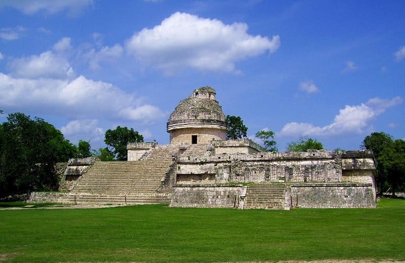
Today, some 2 million tourists visit Chichen Itza annually to explore its architectural wonders and gain further insight into Mayan history and culture. However, archeologists are still at work on the site. As recently as 2016, scientists discovered a smaller pyramid within El Castillo using modern imaging technology. It is believed this smaller structure held religious significance to the Mayans. Text by History.com Editors
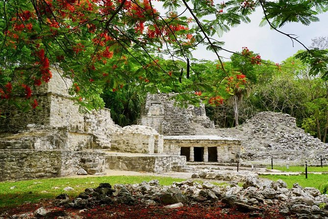
Tulum Mayan Ruins
Tulum was first occupied in the Late Postclassic period, beginning about 1200 AD. Its principal structures are similar to those found at Mayapan. Tulum was an important port and trading center for the Yucatan’s east coast Maya. Considered by many as the most beautiful of the Mayan sites due to its location on the 15 meter high cliffs above the Caribbean ocean. When the Spanish first set eyes on the site in 1518, they considered it as large and beautiful a city as Seville, Spain. They were perhaps misled by their dreams of El Dorado, by the glory of its position, and by the brightly painted facades of the buildings. Architecturally, Tulum is no match for these great cities. Nevertheless, thanks to the setting, it sticks in the memory like no other.
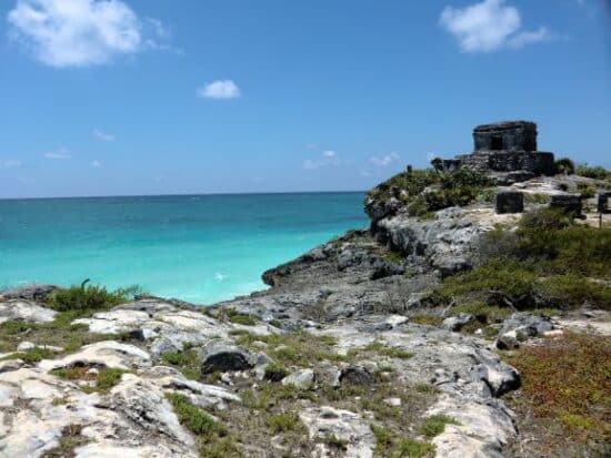
You enter through a breach in the wall which protected the city on three sides. The fourth was defended by the sea. This wall, some 5m (16ft) high with a walkway around the top, may have been defensive, but more likely its prime purpose was to distinguish the ceremonial and administrative zone (the site you see now) from the residential enclaves, which were mostly constructed of perishable material. As you go through the walls, the chief structures lie directly ahead of you, with The Castillo (The Castle) rising on its rocky prominence above the sea.
At The Templo de los Frescos (Temple of the Frescoes), the partly restored murals that can be seen inside the temple depict Mayan Gods and symbols of nature’s fertility; rain, corn and fish. They originally adorned an earlier structure and have been preserved by the construction of a gallery around them, and still later (during the fifteenth century) by the addition of a second temple. Characteristically, its walls slope outwards at the top. Carved on the corners of the gallery are masks of Chac, or perhaps of the creator, God Itzamna.
The Castillo, on the highest part of the site, commands imposing views in every direction. Aside from its role as a temple, it may well have served as a beacon or lighthouse. Even without a light it would have been and important landmark for mariners along an otherwise monotonously featureless coastline. You climb first to a small square, in the middle of which stood an altar, before climbing the broad stairway to the top of the castle itself. To the left of this plaza stands the Templo del Dios Descendente. The diving or descending god-depicted here above the narrow entrance of the temple appears all over Tulum as a small, upside-down figure. His exact significance is not known. He may represent the setting sun, rain, lightning, or he may be the Bee God, since honey was one of the Mayan’s most important exports. Opposite is the Templo de Las Series Iniciales (Temple of the Initial Series), so called because in it was found a stela bearing a date well before the foundation of the city, and presumably brought here from else where.
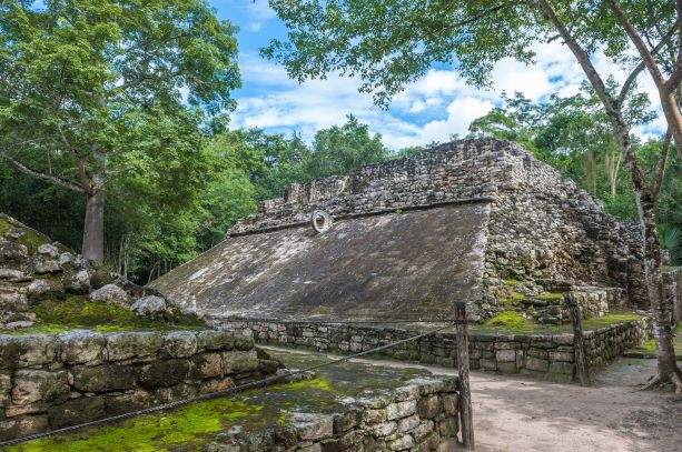
Coba Mayan Ruins
Coba or “Waters Stirred by the Wind”, was built between two lakes during the Classic period (600-900 AD). Its architectural style is closer to the style of the Peten such as Tikal. During it’s peak, Coba had almost 50,000 inhabitants, and covered an enormous area of more than 80 square kilometers. Even though hundreds of structures still remain buried beneath the jungle, archeologists believe Coba was one of the largest Maya cities in the Yucatán, and probably functioned as an important link in trade between the Caribbean and the inland cities.
One of the most interesting features of Coba is the raised roads know as sacbes (Maya for white roads) which connected the entire Peninsula. The roads were built in straight lines, 1 to 2 meters in height, and between 3 and 20 meters wide. They were covered with limestone plaster and frequently included ramps and intersections. One road extends over 100 kilometers, starting at the base of the main pyramid at Coba and ending at Xahuna, south of Chichen Itzá. More than 50 sacbes have been discovered at Coba, all originating at the central Plaza and stretching out in four general directions.
The great pyramid Nohoch Mul (large hill), 42 meters in height, is the highest pyramid in the Yucatán. From the summit dozens of structures covered by the jungle can be detected. The Iglesia or Church is the second highest pyramid and grants a view of Lake Macanox from its summit. Finally, the smaller pyramid of Conjunto Las Pinturas is notable for the mural that once covered its walls, of which traces can be still be seen.
While visiting this Mayan city you can walk up to 10 Km (6 miles), depending on how many ruins you wish to see. Bicycle rentals are offered and it is not a bad idea if you really want to see the site. The village itself has several small native markets and restaurants. Plan to spend most of the day and come early to avoid the jungle heat and beat the crowds. Remember to wear sturdy shoes, insect repellent and bring water. After visiting the ruins you will no doubt want to cool off. On the road back to Tulum you will find Grand Cenote, which is an excellent place for a refreshing swim in a gorgeous jungle setting.
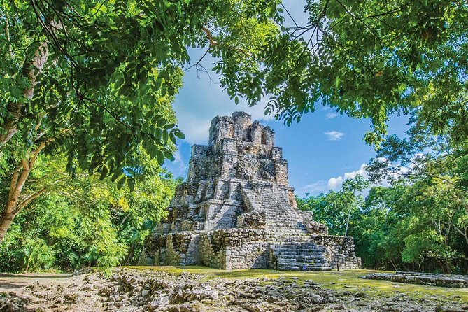
Muyil Mayan Ruins
Believed to be inhabited from 300 BC until the 16th century when Francisco de Montero led the Spanish conquer of the Yucatan. It is estimated that there are 75 temples in the main complex waiting to be uncovered. Today this archaeological site is mostly covered in vegetation, however there are three temples that are quite interesting. Muyil is currently being excavated by the University of the Yucatan when money allows work to continue.
The uncovered area is small and not nearly as impressive as the temples of Chichen Itza, Tulum or Coba, however it is a very nice site to visit since there are few visitors, the stroll through the jungle as you visit the site is very nice and it makes an excellent day trip when tied together with a visit to the Sian Ka’an biosphere or a visit to Grand Cenote.